Building Thanh Hoa City: A Civilized, Modern, and Distinctive Urban Development
Connecting the Economic Region Center
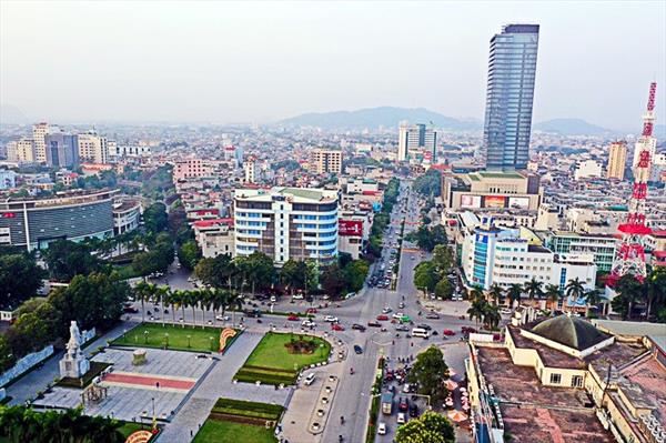
Following the comprehensive urban planning for Thanh Hoa City, Thanh Hoa province, until 2040, will cover the entire area within the administrative boundaries of Thanh Hoa City and Dong Son district, with a total area of approximately 22,821 hectares. This is a highly significant event, opening up new perspectives and creating a new position and impetus for the development of Thanh Hoa City in the future. The planning aims to elevate the role and position of Thanh Hoa city to become the economic connectivity center for the North Central region, connecting with the Red River Delta, Northwest Vietnam, and Northeast Laos. The vision is to develop Thanh Hoa into a civilized, modern, intelligent city with its own identity, suitable for green growth to address climate change, and to leverage the traditions and cultural history of the Mã River Delta and Dong Son culture.
Building Thanh Hoa City as the provincial capital and comprehensive center of Thanh Hoa province is intended to meet the role of a leading hub, connecting and being the driving force for development in all key areas: political, economic, socio-cultural, scientific-technological, and national defense and security.
The urban expansion plan aims to attract investment, develop diverse industries and commercial services, and promote cultural, historical, and ecological tourism. Urban development is oriented towards service-oriented growth, developing land funds for housing and real estate markets, as well as improving and enhancing the quality of technical infrastructure and social infrastructure for the people's quality of life.
Synchronized Development
The urban development structure of Thanh Hoa is established based on inheriting and adjusting the formation structure of Thanh Hoa City and guiding the development direction of the Central Region of Thanh Hoa province, encompassing Thanh Hoa City, Sam Son City, Hoang Hoa district, Quang Xuong district, and Dong Son district.
The adjustment shifts the development model from a "central cross-belt" pattern in Thanh Hoa city to a "belt-open model with a soft network," taking into account the terrain and natural landscape. The central space along Le Loi Avenue is maintained, with reinforced urban strips parallel to the Ma River landscape and the establishment of Ring Road 3 connecting these urban strips. The existing urban center serves as the nucleus, forming the urban structure framework of "3 development axes - 6 centers - 1 natural ecological corridor."
The three main axes include a Traditional Axis (North-South), connecting traditional development areas like Ham Rong, Hac Thanh, and Quan Nam Bridge; a Dynamic Axis (Southwest-Northeast), linking the city center to Tho Xuan airport via Le Loi Avenue and extending to Hai Tien Sea; and an Innovative Axis (Northwest-Southeast), connecting modern urban development areas from Dong Minh interchange to the new Southeast city and linking to the coastal tourist city of Sam Son.
The integrated centers consist of six main centers, including the existing administrative and political center, a center focused on tourism, historical and cultural heritage, a sports and fitness center, a regional commerce center, an industrial and transportation services center, and an urban agriculture and healthcare service center.
A natural ecological corridor is established on both sides of the Ma River, creating parks in harmony with hydrological and landscape conditions along the river. The Ham Rong - Do Mountain area becomes the main open space of Thanh Hoa. In each area associated with integrated centers, open spaces are designed in collaboration with existing hill and river landscapes, such as Nui Rung Thong, Nui Nhoi, Mat Son, Hoang River system, Ly River, Nha Le River, and Thong Nhat River. Completing parks and squares in the central area, including Hoi An Park, Thanh Quang Park, Dong Chiec Lake Park, Nam Thanh Pho Urban Area Park, Van Hoa Park of Thanh Land, amusement parks in the Ham Rong - Do Mountain area, and other regional parks and squares.